


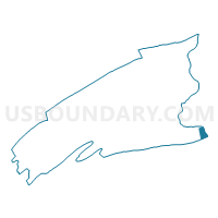
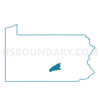
MARYSVILLE Voting District, Perry County, Pennsylvania
About
Outline

Summary
| Unique Area Identifier | 661957 |
| Name | MARYSVILLE Voting District |
| County | Perry County |
| State | Pennsylvania |
| Area (square miles) | 2.34 |
| Land Area (square miles) | 2.33 |
| Water Area (square miles) | 0.00 |
| % of Land Area | 99.81 |
| % of Water Area | 0.19 |
| Latitude of the Internal Point | 40.33762860 |
| Longtitude of the Internal Point | -76.93206900 |
Maps

Graphs
Select a template below for downloading or customizing gragh for MARYSVILLE Voting District, Perry County, Pennsylvania


Neighbors
Neighoring Voting District (by Name) Neighboring Voting District on the Map
- EAST PENNSBORO TWP PCT 10, Cumberland County, PA
- MIDDLE PAXTON TWP DIST 02, Dauphin County, PA
- MIDDLE PAXTON TWP DIST 03, Dauphin County, PA
- PENN TWP Voting District, Perry County, PA
- RYE TWP Voting District, Perry County, PA
- SUSQUEHANNA TWP WD 01, Dauphin County, PA
- SUSQUEHANNA TWP WD 02, Dauphin County, PA
Top 10 Neighboring County Subdivision (by Population) Neighboring County Subdivision on the Map
- Susquehanna township, Dauphin County, PA (24,036)
- East Pennsboro township, Cumberland County, PA (20,228)
- Middle Paxton township, Dauphin County, PA (4,976)
- Penn township, Perry County, PA (3,225)
- Marysville borough, Perry County, PA (2,534)
- Rye township, Perry County, PA (2,364)
Top 10 Neighboring Place (by Population) Neighboring Place on the Map
Top 10 Neighboring Unified School District (by Population) Neighboring Unified School District on the Map
- Central Dauphin School District, PA (90,401)
- Susquehanna Township School District, PA (24,036)
- East Pennsboro Area School District, PA (20,228)
- Susquenita School District, PA (14,612)
Top 10 Neighboring State Legislative District Lower Chamber (by Population) Neighboring State Legislative District Lower Chamber on the Map
- State House District 87, PA (71,639)
- State House District 86, PA (66,211)
- State House District 104, PA (64,451)
Top 10 Neighboring State Legislative District Upper Chamber (by Population) Neighboring State Legislative District Upper Chamber on the Map
- State Senate District 31, PA (275,796)
- State Senate District 34, PA (268,795)
- State Senate District 15, PA (266,253)
Top 10 Neighboring 111th Congressional District (by Population) Neighboring 111th Congressional District on the Map
- Congressional District 19, PA (728,630)
- Congressional District 17, PA (681,835)
- Congressional District 9, PA (666,810)
Top 10 Neighboring Census Tract (by Population) Neighboring Census Tract on the Map
- Census Tract 247, Dauphin County, PA (5,998)
- Census Tract 101, Cumberland County, PA (5,411)
- Census Tract 102.01, Cumberland County, PA (5,162)
- Census Tract 304, Perry County, PA (4,898)
- Census Tract 303.01, Perry County, PA (4,747)
- Census Tract 219.01, Dauphin County, PA (4,407)
- Census Tract 218, Dauphin County, PA (2,296)